
Press release 18 June 2026, for immediate release
Ministers urged to ensure new homes reduce car-dependence
Local authority associations and other groups with interests in health, the environment and sustainable transport have urged Ministers to do more to ensure new homes help reverse the growth of motor traffic, rather than worsening it, by ensuring that they are located and designed to support travel by walking, cycling, public and shared transport.
In a letter to Communities Secretary Steve Reed MP [1], the organisations call for changes to planning policy that would “concentrate more homes on less land, in places where demand is strongest, enabling people to make more of their day-to-day journeys without feeling their only option is to drive, or that their opportunities in life are hindered if they cannot do so.”
They point to evidence showing that the planning system “continues to deliver low density housing in locations with poor sustainable transport connectivity and few local amenities”, causing “a wide range of adverse economic, environmental and social impacts.” They note that the space taken up by roads and car parking in such developments “reduces the number of people within a short walk of schools, shops and other local amenities, while also making it harder to provide frequent, economically-viable public transport services.” This all significantly increases the levels of motor traffic on our roads.
They acknowledge that the Government’s concept of ‘vision-led planning’, adopted in the current version of the National Planning Policy Framework (NPPF) [2], was intended to tackle these problems. However they say that this has been insufficient to turn the tide, citing the example of Selwood Garden Community, a development of 1,700 homes in Frome, Somerset. This was recently granted permission despite consisting of low-density homes, located off the A361 bypass, with long, steep and poorly-connected walking routes to schools, supermarkets and other town centre destinations. The transport funding from the development will mainly be used to enlarge junctions on the nearby A36, with minimal improvements being made for walking or cycling, public or shared transport. Yet the Public Inquiry inspector uncritically accepted the developer’s predictions of unfeasibly high use of these modes [3].
The letter notes that these claims received none of the scrutiny that would normally occur at a Local Plan public inquiry because, like many under-resourced local councils [4], Somerset has faced obstacles to completing its Local Plan, with enough land allocated to meet its housing targets. This has left it vulnerable to speculative development. The NPPF then makes it very hard to reject such development, even where it clearly consists of “the wrong homes in the wrong places”, contrary to the Government’s aims to promote urban regeneration.
The organisations call for three amendments to the NPPF, which was recently subject to consultation. They urge Steve Reed to:
- Amend the “presumption in favour of sustainable development”, to ensure it does not impede proper democratic scrutiny and sound decision-making. Citing concerns that the latest draft NPPF could make things worse, they urge that “Development proposals whose adverse effects demonstrably outweigh the benefits must be capable of being rejected.”
- Develop an objective test that shows developers, councils and communities alike what constitutes a genuinely ‘vision-led’ development, using the Department for Transport’s Connectivity Tool [5]. This can identify how easy or hard it is to reach key destinations (schools, shops etc) from a proposed development (or site) by walking, cycling and public transport. Hence it can be used to support developments that would reduce car-dependence, while avoiding developments that would worsen it.
- Adopt the Connectivity Tool in preference to a policy proposed in the draft NPPF that would effectively give the green light to developments near rail stations, particularly those which are “well connected”. Although the signatories voice support for the principle of concentrating development in such locations, they fear the NPPF policy as drafted could result in inappropriate developments that fail to make best use of these key sites, and missed opportunities to maximise connectivity by walking and cycling as well as public transport. Using the Connectivity Tool instead would yield much better outcomes.
The letter concludes by stating that, “Paradoxically, making it easier for councils to reject poorly-connected developments could increase the amount of housing brought forward, concentrating it on less land but in places where it is most needed (particularly by those seeking affordable accommodation) and where it would carry much greater public support. Ensuring we build ‘the right homes in the right places’ would help avoid the huge economic and other costs of continuing to do the opposite.”
—-
Notes to editors
[1] The signatories to the letter include representatives of the National Association of Local Councils (NALC), UK100, CPRE the countryside charity, Mums for Lungs, Transport Action Network (TAN), Transport for New Homes and the Better Planning Coalition (BPC). It was coordinated by BPC and the Low Traffic Future alliance (which is hosted by TAN). The joint letter and full list of signatory organisations can be viewed here.
[2] The National Planning Policy Framework (NPPF) outlines policies that planning authorities must have regard to when preparing Spatial Development Strategies or Local Plans, and when taking planning decisions. The current version, adopted in December 2024, includes the concept of ‘vision-led development’. This was intended as an alternative to the ‘predict and provide’ approach to transport planning, in which predictions were made of the motor traffic likely to be generated by a development, and road-space or junction capacity was provided to accommodate it. This approach tended to be self-fulfilling, as additional road-space tends to generate additional motor-traffic. Although the signatories to the letter regard the ‘vision-led’ approach as a positive step in principle, they feel the ‘vision’ is unclear, leaving developers or local authorities free to decide what they want it to mean. Hence the need for a clearer test, using the Connectivity Tool, that can objectively identify what developments or sites are genuinely ‘vision-led’. Consultation on an updated NPPF was conducted in early 2026, with a new version expected soon.
[3] A briefing from Transport for New Homes, outlining the problems with the Selwood Garden Community development, can be found here.
[4] Less than a third of England’s local planning authorities have an up-to-date Local Plan – see www.gov.uk/government/news/new-local-plan-system-launching-early-2026-latest-update.
[5] The Connectivity Tool, developed by the Department for Transport (DfT), is at www.gov.uk/guidance/connectivity-tool. It was referenced in the Government’s recent consultation draft on an updated NPPF. However the draft provided no guidance on how local authorities should use the Tool to support decisions on what are, or are not, suitable developments or locations from a sustainable transport perspective.
Contact details
For further information, contact:
Roger Geffen, joint-coordinator, Low Traffic Future alliance
roger@lowtrafficfuture.org.uk or 07547 029171
– or –
Richard Hebditch, Convenor, Better Planning Coalition
richard@betterplanningcoalition.com or 07970 177441.
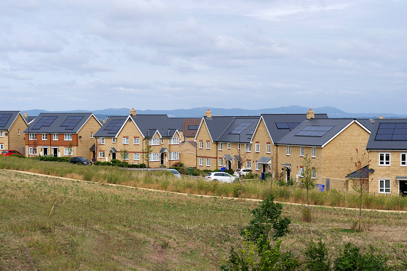
Photo: New Housing Development on the North Side of Bishop’s Cleeve © Copyright David Dixon and licensed for reuse under this Creative Commons Licence.